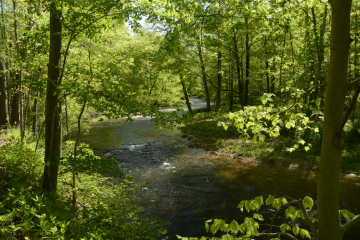
Site Description

Site ID: BR07
Mine Hill, Morris County
Stream Category: FW2-NT (Category 2, Non-trout waters)
Site monitors Lamington River (above Route 10) subwatershed (HUC: 02030105030050)
This site is located behind the QuickChek off of Route 46 in Mine Hill. This site is located immediately downstream of the former Hercules Powder Plant.

This site is located just below the headwaters of the Lamington River, known locally as the “Great Spring.”

What is being monitored at this site?

  • Biological and Visual Assessments (?)
  • Chemical Testing (?)

Interactive Map: Under Legend, click on layers to turn them on/off. Click on > to view definitions. If a layer is greyed out, use the +/mouse to zoom in to activate. Click on map layers to get detailed information.

Water Quality Data

Each June, Raritan Headwaters scientists and volunteers visit 72 stream sites in the North and South Branch Raritan Watershed Region (WMA8) of New Jersey to collect data on the health of our streams.  Data collected includes a sample of benthic macroinvertebrates (used to calculate the High Gradient Macroinvertebrate Index;HGMI score), an assessment of the habitat in and around the stream, and chemical conditions in the water.  Chemical parameters include dissolved oxygen, phosphate, chloride, specific conductance, nitrate, turbidity, pH, and temperature. The HGMI is used by the NJ Department of Environmental Protection (NJDEP) and the US Environmental Protection Agency (USEPA) to determine if the site is meeting state and national water quality standards under the Clean Water Act. Click here to learn more about our stream monitoring program and water quality reports.


Site Data for BR07

Select a parameter below to view annual data. Hover over the chart to get more information.

Threats and Recommendations

The HGMI at BR07 was found to be fair in 2019, which means it was biologically impaired. Because BR07 has been consistently impaired based on the HGMI for more than 2 years, it is part of our quarterly chemical monitoring program so that we can begin to identify and address the causes of impairment. This site is located below the former Hercules Powder Plant, Kenvil site, now undergoing site remediation for a variety of contaminants including TNT, PCBs, lead and arsenic.  Much of the sites has now reverted to forests and there are extensive wetlands associated with springs on the property, where the Black River originates.  Soil, surface water and groundwater contaminants are present on the property and likely impacting the BR07.  The biggest water quality issue that we found at this site were chloride and specific conductance, which are both measures of the salt content of the water. Most of the chloride in freshwater streams comes from run-off of road salts into waterways during the winter months. Chloride can also leach into the groundwater and find its way back to the surface water later in the year, meaning that chloride can remain high even when road salting isn’t active.

BR07

BR07

Google Map View

Latest News About Water Quality