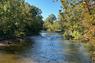
Site Description

Site ID: BR06
Bedminster Township, Somerset County
Stream Category: FW2-NT (Category 2, Non-trout waters)
Site monitors Lamington River (Halls Bridge Road to Herzog Brook)  subwatershed (HUC: 02030105050070)
The site is located upstream of Cowperthwaite Road bridge near the intersection of Milnor Road. This site is located on the Burnt Mills Preserve owned and managed by Raritan Headwaters Association.

What is being monitored at this site?

  • Biological and Visual Assessments (?)
  • Chemical Testing (?)

Water Quality Data

Each June, Raritan Headwaters scientists and volunteers visit 72 stream sites in the North and South Branch Raritan Watershed Region (WMA8) of New Jersey to collect data on the health of our streams.  Data collected includes a sample of benthic macroinvertebrates (used to calculate the High Gradient Macroinvertebrate Index;HGMI score), an assessment of the habitat in and around the stream, and chemical conditions in the water.  Chemical parameters include dissolved oxygen, phosphate, chloride, specific conductance, nitrate, turbidity, pH, and temperature. The HGMI is used by the NJ Department of Environmental Protection (NJDEP) and the US Environmental Protection Agency (USEPA) to determine if the site is meeting state and national water quality standards under the Clean Water Act. Click here to learn more about our stream monitoring program and water quality reports.


Site Data for BR06

Select a parameter below to view annual data. Hover over the chart to get more information.

Threats and Recommendations

The HGMI at BR06 was found to be good in 2019, which means it was not biologically impaired. This site is located on a nature preserve and is the previous site of a breached dam, the Burnt Mills Dam. This breached dam structure caused the flow of the river to move outward, away from the dam and it’s natural channel, and form a second, dominant stream channel. This new channel was eroding heavily and causing flooding damage to nearby properties. After the 2019 stream monitoring season, the old dam structure was removed and the stream was restored to it’s original channel; the second channel previously created by the dam will be used as an overflow channel during high flow events.  A variety of habitat features, such a riffles and plunge pools, were restored to this site. We hope to see an improvement in the water quality at this site following the dam removal.

BR06

BR06

Google Map View

Latest News About Water Quality